back to previous page GRAND FALLS the giant steps

Horseshoe Bend
Grand Falls
Location: northwest of Leupp, Navajo Reservation, Northern Arizona
Distance: 39 miles from Flagstaff (via IR 6910)
Opening hours: no restrictions
Fees/Admission: no
Direction: from Flagstaff go east on I-40 for about 8 miles to Exit 211 (Winona), there go 2.3 miles north to Leupp Road (Indian Rd. 15), make a right and follow the Leupp Road for 20 miles to Indian Road 6910 (between MM 5 and 6), turn left onto it and follow this unpaved and rough road for about 9 miles to the turnoff on the left to the falls overlook (ramadas) - just before you hit the Little Colorado River (see link for 'Area Map' below).
There is another unpaved access road (from Leupp Rd.) to the Grand Falls, the Indian Road 70. The turnoff onto this road is about 5.2 miles west of the 6910 turnoff (close to the cinder cones of the Merriam and Sheba Craters).
Both access roads join about a mile south of the river.
I drove the IR 6910 to the falls and the IR 70 back. Both are rough roads, 4WD recommended, maybe unpassable by rain.

Grand Falls. The falls, higher than the Niagara Falls, are located on Navajo land and most of the year dry. The muddy water of the Little Colorado River flows over the two gigantic steps only during (and shortly after) heavy and long lasting rain or in spring at the time of the snow melt.
150.000 years ago this very interesting spot was created by the lava flow of the Merriam Crater (about 10 mile away) when the flow reached the original river bed and filled it up, building a natural dam. The river 'found' a northern detour around the lava flow before it went back into its original riverbed at the location of the Grand Falls.

Little Colorado River
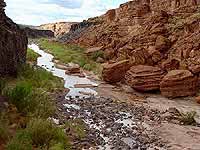
Crossing the Little Colorado River
The visit. The best place to enjoy the view of the Grand Falls is from the overlook at the ramadas but you can also walk to the northwest side of the falls (if the crossing of the river bed above the falls is dry) or hike down a trail to the bottom of the falls.
This trail starts at the rim west of the overlook and heads down to the Gaging Station. There it turns right and leads to the bottom of the Grand Falls. A short and interesting hike you should not miss if the muddy river is not flowing.

Be careful - there are no hand rails or any other safety devices at the rims. Be aware of the danger!

Map. The following link opens in a new window and shows you an area map of the Grand Falls area (USGS Grand Falls Quad):
Area Map of the Grand Falls, 1:50.000, provided by TopoZone.com (on the map you can see the detour of the Little Colorado River around the lava flow of the Merriam Crater)

Downstream the Grand Falls
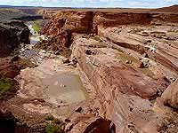
Downstream river bed,
below the Grand Falls
Grand Falls
On the trail to the bottom
of the falls

Grand Falls, Little Colorado River
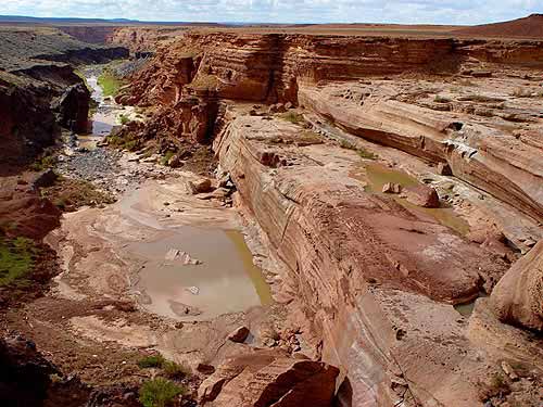
Grand Falls & the lower river bed of the Little Colorado River
(enlargeable)

All photos: © by gbintheworld.com
All information: as of spring 2004

Nearby attractions:
Please visit the page Trips and Sightseeing in northern Arizona for other interesting parks, monuments and places north of Phoenix.

Links to websites and info about the Grand Falls (links open in a new window):
Grand Falls Geology of Arizona - ASU E
Grand Falls waypoint info & links, provided by wayhoo.com E

[BACK]

send to printer


Website Orientation:
> Home/Welcome
  > EXTRA!!! my magazine
    > Trips & Hiking
      > Trips and Sightseeing, Northern Arizona
        > Grand Falls (= you are here)

[Welcome]  [USA Austria]  [EXTRA - my magazine]  [Webcam Links]  [Link Collection]
[About me]  [Photo Collections]  [Downloads]  [Disclaimer]  [Sitemap]  [Guestbook]  [Email]


back to top back to previous page Home - www.gbintheworld.com If you didn't get to this page through the mainpage ('choose a language')
of gbintheworld.com then please click here!!!

© gbintheworld


Datenschutzerklärung